Adair County, MO

Headnote

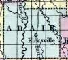
ADAIR COUNTY, in the northern part of Missouri, and traversed by Chariton river. Area --- square miles. Courts are held at Kirksville. Pop.,in 1850, 2,342. (Fanning's, 1853)

ADAIR, a county in N. N. E. part of Missouri, has an area of 570 square miles. It is intersected by Chariton river and by the North Fork of Salt river. The surface presents no great elevations ; the soil is generally fertile, adapted to grain and grass. It produced in 1850, 141,370 bushels of Indian corn; 5801 of wheat; 11,157 of oats, and 32,605 of butter. Organized about the year 1840. Capital, Kirksville. Population, free 2298, slaves 53 ; total 2351. (Baldwin & Thomas, A New and Complete Gazetteer of the United States ... 1854)

    Place Unit Type
    County
    Containing Unit
    Name Type
    Kirksville, MO City or Town
    How to Cite This Page: "Adair County, MO," House Divided: The Civil War Research Engine at Dickinson College, https://hd.housedivided.dickinson.edu/index.php/node/14519.