BOONE COUNTY, in the central part of Missouri, on the northeasterly side of Missouri river. Area, 600 square miles. Face of the country undulating. Soil, generally good. Seat of justice, Columbia. Pop. in 1830, 8,859; in 1840, 13,561; in 1850, 14,979. (Fanning's, 1853)
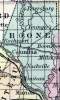
BOONE, a county in the N. central part of Missouri, has an area of 648 square miles. It is bounded on the S. W. by the Missouri river, and on the E. by Cedar creek, and traversed by Roche Percée and Petite Bonne Femme rivers, which flow nearly southward into the Missouri. The surface is moderately diversified, and consists partly of prairie and partly of timbered land : the soil is uniformly and highly productive, and extensively cultivated. Indian corn, wheat, oats, tobacco, hemp, cattle, and pork are the staples. In 1850 this county produced 1,001,983 bushels of corn; 70,163 of wheat; 80,543 of oats; 584,949 pounds of tobacco, and 51 tons of hemp. It contained 51 churches, and 1 newspaper establishment. There were 2460 pupils attending public schools. Stone coal and limestone are found in the county. Boone county is one of the most populous in the state. Capital, Columbia. Population, 14,979, of whom 11,313 were free, and 3666, slaves. (Baldwin & Thomas, A New and Complete Gazetteer of the United States ... 1854)