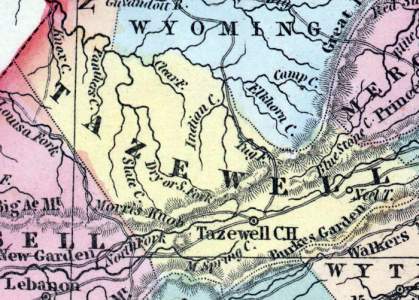
Tazewell County, Virginia (Howe)
Gazetteer/Almanac
TAZEWELL was formed in 1799, from Russell and Wythe, and named from Henry Tazewell, a member of the U. S. Senate, from 1794 to 1799. It is 60 miles long, with a mean width of 25 miles. The Tug Fork of Big Sandy runs on part of the northern border; the Clinch River rises near Jeffersonville, and the Great Kanawha receives many branches from the eastern section of the county. It is traversed by mountains, some of which rise to an immense height; the chief are, Clinch, Rich, East River, and Paint Lick. Between some of them are beautiful valleys, of a black, deep soil, very fertile. Abb's Valley, a delightful tract, 10 miles long, and about 40 rods wide, with no stream running through it, and bounded by lofty mountains, possesses a soil of extraordinary fertility. It derives its name from Absalom Looney, a hunter, who is supposed to have been the first white person ever in it. Inexhaustible quarries of limestone exist in the county, and extensive beds of excellent coal. The principal staples are cattle, horses, hogs, feathers, tow and flax linen, beeswax, ginseng, seneca snakeroot, &c., &c. The mean height of the arable soil is about 2,200 feet above the level of the ocean. Pop. in 1840, whites 5,466, slaves 786, colored 38; total, 6,590.
Henry Howe, Historical Collections of Virginia… (Charleston, SC: William R. Babcock, 1852), 487-488.


