Scott County, Virginia (Howe)
Gazetteer/Almanac
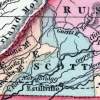
SCOTT was formed in 1814, from Lee, Washington, and Russell, and named from Gen. Winfield Scott: its mean length is 24, mean breadth 23 miles. It is drained by the north fork of Holston and Clinch Rivers, each of which affords the facilities of boat navigation in times of freshets. Big and Little Moccasin and Sinking creeks, also water the county. The face of the country is mountainous and uneven, and much of the soil is good. Iron, coal, marble, limestone, and freestone, are found within its limits. About 60,000 pounds of maple sugar are annually produced. Pop. in 1840, whites 6,911, slaves 344, free colored 48; total, 7,303.
Henry Howe, Historical Collections of Virginia… (Charleston, SC: William R. Babcock, 1852), 464.