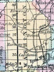
POTOSI, a post-village, capital of Washington county, I\Iissouri, about 70 miles S. S. W. from St. Louis. It contains, besides the county buildings, several churches, and an academy. Rich mines of lead (in the form of sulphuret) and of iron are worked in the vicinity. The lead ore yields 70 or 80 per cent, of metal. (Baldwin & Thomas, A New and Complete Gazetteer of the United States ... 1854)
POTOSI, The county seat of Washington county, on Burton creek, in Breton township, 65 miles from St. Louis, and 101 miles from Jefferson City. It was first settled in the year 1763, by Messrs. Reunault and Moses, and is one of the oldest places in the State. It is only four miles from the Iron Mountain Rail Road, and the same distance from Mineral Point stage route. A rail road track has lately been laid from the Iron Mountain Rail Road to this town, and trains are running daily. Uncultivated lands in this vicinity are worth about $12.50 per acre; cultivated lands are worth from $12 to $15 per acre. Timber, common to this country , is pine, oak, and hickory. The chief products are wheat, corn, oats and rye. The country abounds in lead mines of the richest kind. Potosi has four churches, Methodist, Baptist, Presbyterian and Catholic; one Masonic Lodge, Potosi Lodge, No. 131, one Odd Fellow's Lodge, Fidelity Lodge, No. 78, and two good common schools. Population about 650. (The Missouri State Gazetteer and Business Directory, 1860)

