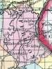
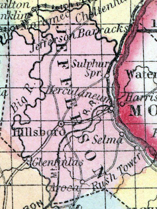
Jefferson County, MO

Headnote

JEFFERSON COUNTY, situated on the easterly boundary of Missouri, with Mississippi river on the east. Area, 500 square miles. Face of the country broken; soil generally sterile. Seat of justice, Hillsborough. Pop. in 1820, 1,835; in 1830, 2,586; in 1840, 4,296; in 1850, 6,928. (Fanning's, 1853)

JEFFERSON, a county in the E. part of Missouri, bordering on the Mississippi river, which separates it from Illinois, has an area of 654 square miles. Big river flows through the county from south to north, and falls into the Maramec, which forms part of the northern boundary. The county is also drained by Plattin, Joachim, and Sandy creeks. The northern and eastern parts are generally level and fertile ; the western portion is hilly and sterile, Indian corn, wheat, oats, hay, cattle, and pork are the staples. In 1850 this county produced 289,116 bushels of corn; 17,322 of wheat; 35,441 of oats; and 751 tons of hay. It contained 5 churches, and 281 pupils attending public schools. The hills contain rich mines of lead ; copper and cobalt are found in smaller quantities. The Mammoth mine has yielded many thousand pounds of lead. Capital, Hillsborough. Population, 6928, of whom 6416 were free, and 512, slaves. (Baldwin & Thomas, A New and Complete Gazetteer of the United States ... 1854)

    Place Unit Type
    County
    Containing Unit
    Name Type
    De Soto, MO City or Town
    Herculaneum, MO City or Town
    Hillsboro, MO City or Town
    How to Cite This Page: "Jefferson County, MO," House Divided: The Civil War Research Engine at Dickinson College, https://hd.housedivided.dickinson.edu/index.php/node/21118.