Gazetteer/Almanac
Headnote
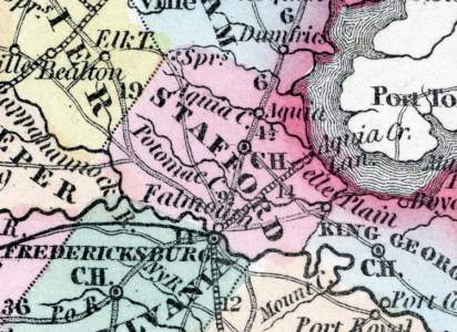
Its length is 20, mean width 12 miles. The Rappahannock runs on its SW. border, the Potomac on its E. boundary; the rail-road from Fredericksburg to the Potomac runs through it. On the streams there is considerable good land, elsewhere the soil is generally worn out by injudicious agriculture. Gold exists in the county. Pop. in 1840, whites 4,489, slaves 3,596, free colored 369; total 8,454. (Historical Collections, 1852)
Note Cards
Stafford County, Virginia (Fanning's, 1853)
STAFFORD COUNTY, situated on the easterly boundary of Virginia, with Potomac on the east, and the Rappahannock on the southwest. Area, 335 square miles. Face of the country, hilly; soil, sandy. Seat of justice, Stafford, c.h. Pop. in 1810, 9,830; in 1820, 9,517; in 1830, 9,362; in 1840, 8,454; in 1850, 8,044.
Fanning's Illustrated Gazetteer of the United States.... (New York: Phelps, Fanning & Co., 1853), 343.
Stafford County, Virginia (Howe)
Gazetteer/Almanac
STAFFORD was formed in 1675, from Westmoreland. Its length is 20, mean width 12 miles. The Rappahannock runs on its SW. border, the Potomac on its E. boundary; the rail-road from Fredericksburg to the Potomac runs through it. On the streams there is considerable good land, elsewhere the soil is generally worn out by injudicious agriculture. Gold exists in the county. Pop. in 1840, whites 4,489, slaves 3,596, free colored 369; total 8,454.
Henry Howe, Historical Collections of Virginia… (Charleston, SC: William R. Babcock, 1852), 484.
Events
Date | Type | |
---|---|---|
Anthony Burns is born in Stafford County, Virginia | Personal | |
Moncure Conway is born in Stafford County, Virginia | Personal | |
Moncure Conway liberates his father's slaves | Personal |
People
Places
Name | Type |
---|---|
Aquia Creek Landing, VA | Location or Site |
Aquia, VA | City or Town |
Falmouth, VA | City or Town |