Ralls County, MO

Headnote

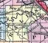
RALLS COUNTY, situated on the easterly boundary of Missouri, with Mississippi river on the east, and traversed by Salt river. Area, 470 square miles. Face of the country, uneven; soil, productive. Seat of justice, New London. Pop. in 1830, 4,375; in 1840, 5,670; in 1850, 6,151. (Fanning's, 1853)

RALLS, a county in the E. N. E. part of Missouri, contains about 430 square miles. It is bounded on the N. E. by the Mississippi, which separates it from Illinois, traversed from W. to E. by Salt river, and also drained by Spencer's and Lick creeks. The surface is somewhat diversified, and the soil generally good. Originally, about three-fourths of the surface was covered with forests of hard wood. Indian corn, wheat, oats, hay, cattle, and swine are the staples. In 1850 the county produced 495,435 bushels of corn; 
61,427 of wheat; 49,603 of oats; 2291 tons of hay, and 78,274 pounds of butter. There were 15 churches, and 1428 pupils attending public schools. Limestone underlies the greater part of the county. Stone coal and iron ore are found in it. Capital, New London. Population, 6151 ; of whom 4783 were free, and 1368, slaves. (Baldwin & Thomas, A New and Complete Gazetteer of the United States ... 1854)

    Place Unit Type
    County
    Containing Unit
    Name Type
    New London, MO City or Town
    How to Cite This Page: "Ralls County, MO," House Divided: The Civil War Research Engine at Dickinson College, https://hd.housedivided.dickinson.edu/node/28273.