IOWA (Hayward)
Gazetteer/Almanac
IOWA, recently a dependency of the United States, is now an admitted member of the Federal Union. Until 1832, the country was held in undisputed possession by its rude and roaming Indian inhabitants, of whom it was then purchased ; and settlements were soon thereafter commenced by civilized emigrants. In 1838, having been set off from Wisconsin; it was organized under a distinct territorial government; and in 1846, the territory was duly elevated to the position of a free and independent American state.
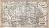
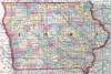
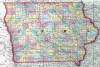
Boundary and Extent. — Iowa is bounded north by the Territory of Minnesota; east by the Mississippi River, which separates it from the States of Wisconsin and Illinois; south by the State of Missouri; and west and north-west by portions of the Territories of Nebraska and Minnesota, from which it is separated by the Missouri and the Big Sioux Rivers. The country lies between 40° 30' and 43° 30' north latitude, and extends from 90° 30' to 96° 30' west longitude; reaching some 200 miles from north to south, with an average extent of over 220 miles from east to west, and comprehending about 51,000 square miles.
Government. — The executive power resides in a governor and lieutenant governor, chosen by popular vote for two years : the latter is president of the Senate. The legislature comprises a Senate and House of Representatives, the former chosen for four years, one half biennially, and in number not less than one third nor more than one half that of the other branch. The constitution provides that the House of Representatives shall not consist of less than 26 nor more than 39 members, until the white population shall amount to 125,000 ; when the minimum shall be 36, and the maximum 72. All free white male American citizens, after a residence of six months, are voters.
Judiciary. — The Supreme Court is composed of a chief justice and two associates, either two of whom form a quorum. They are elected by joint vote of the legislature for six years. District judges are elected for five years by the people, in the several districts. Probate judges, prosecuting attorneys, and clerks of courts are also elected in the same manner, every two years.
Education. — A superintendent of public instruction is chosen by the people for three years. A large school fund is secured by the appropriation of lands granted by Congress, escheated estates, and the percentage allowed by Congress on sales of public lands within the state. Common schools in all the school districts are also maintained, by law, from other sources of revenue. There is also a large fund assigned for the support of a university. The permanent school fund, at interest, in 1850, amounted to about $279,000.
Finances. — The state holds productive property valued at upwards of $11,000,000. Its debt, in 1849, was $55,000, incurring an interest of $5500. The legislature holding biennial sessions only, the annual public expenditure is only about $19,000. The taxable property, in 1849, was valued at $18,479,751, which pays to the state a tax of three tenths of one per cent.
Surface and Soil. — With the exception of some high hills in the northern part, the surface is nowhere mountainous, but consists of table lands, prairies, and gently swelling eminences covered with timber. Ranges of bluffs, from 30 to 120 feet in height, intersected with ravines, generally terminate the table lands upon the borders of rivers. The soil is almost universally good, reaching to a depth of 18 to 24 inches on the upland prairies, and from 24 to 48 inches on the bottom lands. Constant cultivation for a century would scarcely exhaust it. It produces every description of grain and vegetables suited to the climate, and is peculiarly favorable to the growth of fruit. Timber is not abundant, except in certain sections, comprising in all about one fourth part of the state. But the country is so well supplied with river navigation, that this deficiency in other quarters is not felt. Among the indigenous fruits are vast quantities of plums, grapes, strawberries, crab apples, &c. The crops of wheat ordinarily amount to 30 or 35 bushels per acre ; and the yield of corn is from 50 to 75 bushels. Wells of excellent water are obtained at a depth of 25 to 30 feet.
Rivers. — Besides the noble rivers which skirt the state on the east and west, there are several streams of considerable magnitude, with numerous branches, pervading the entire territory. Many of them are extensively navigable, and afford fine water power; and all are immediately or remotely connected with the Mississippi or the Missouri.
Internal Improvements. — A project for constructing a railroad, commencing at Dubuque, on the Mississippi, and extending across the Rocky Mountains to the waters of Columbia River, was started in 1840. At the last session of the General Assembly, acts were passed granting the right of way to the Davenport, Camanche, and Lyons Railroad Companies, for railroads from the Mississippi to Council Bluffs on the Missouri. In these enterprises considerable northern and eastern capital will probably be employed.
Minerals. — But little comparative progress has been made in the exploration and development of the mineral treasures of Iowa; although it is well known, from even imperfect researches, that a very large portion of the country is extremely rich in various descriptions of metals. There are tracts, probably to the extent of hundreds of miles, that abound in load ore; copper and iron are also abundant in various locations, as well as coal, limestone, & In the vicinity of Dubuque, the largest town in the state, are some of the finest and most valuable lead mines in the United States.
Manufactures. — Excepting the working of mineral ores into marketable shape, and the fabrication of articles for domestic use from the raw materials produced within the state, there are no extensive manufacturing operations. The whole amount of capital employed in 1840, in every description of manufactures, fell somewhat short of $200,000.
Indians. — Recently large tracts were held by various tribes of Indians. The lowas held portions of the south, the Pottawatamies of the west, and the Sacs and Foxes of the central parts of the state. But these tracts have been ceeded to the United States.
Population. — Since the admission of Iowa into the Union, the state has been rapidly filling up with white settlers. In 1840, the population numbered 43,112, including that of the north section, now called the Territory of Minesota. It has increased prodigiously within the past ten years, and at the last census amounted to 192,214.
Climate. — With the exception of some localities on the river sides, subject to occasional inundations, the climate of Iowa is more healthy in general than that of the neighboring Western States. This is accounted for by the fact, that the current of its streams is more rapid. The diseases prevalent in quarters considered unhealthy at times are fevers and agues, bilious disorders, &tc. The commencement, duration, and termination of winter correspond with those of the same season in New England. But the temperature is less severe, being more like that of Pennsylvania. Snow, to a depth of more than seven or eight inches, is seldom seen. The summers are extremely pleasant, the heat rarely becoming oppressive, and the atmosphere being often refreshed by gentle showers.
Religion. — Methodists, Presbyterians, and Baptists are the most numerous of the religious denominations. The Episcopalians have several societies or parishes, and there are also Roman Catholics, Friends, &c.
Curiosities. — One of the most remarkable productions of nature, in this region, is a natural bridge, which crosses the River Maksqueta — a fine stream flowing into the Mississippi, near the centre of the eastern boundary of the state. This bridge has a span of 40 feet, and is composed of solid limestone.
John Hayward, Gazetteer of the United States of America… (Philadelphia: James L. Gihon, 1854), 56-58.